Second Anglo Boer War: Jansenville Fort
1899 – 1902: Second Anglo Boer War: Jansenville Fort
Compiled by Wolfgang Witschas

Historical Background
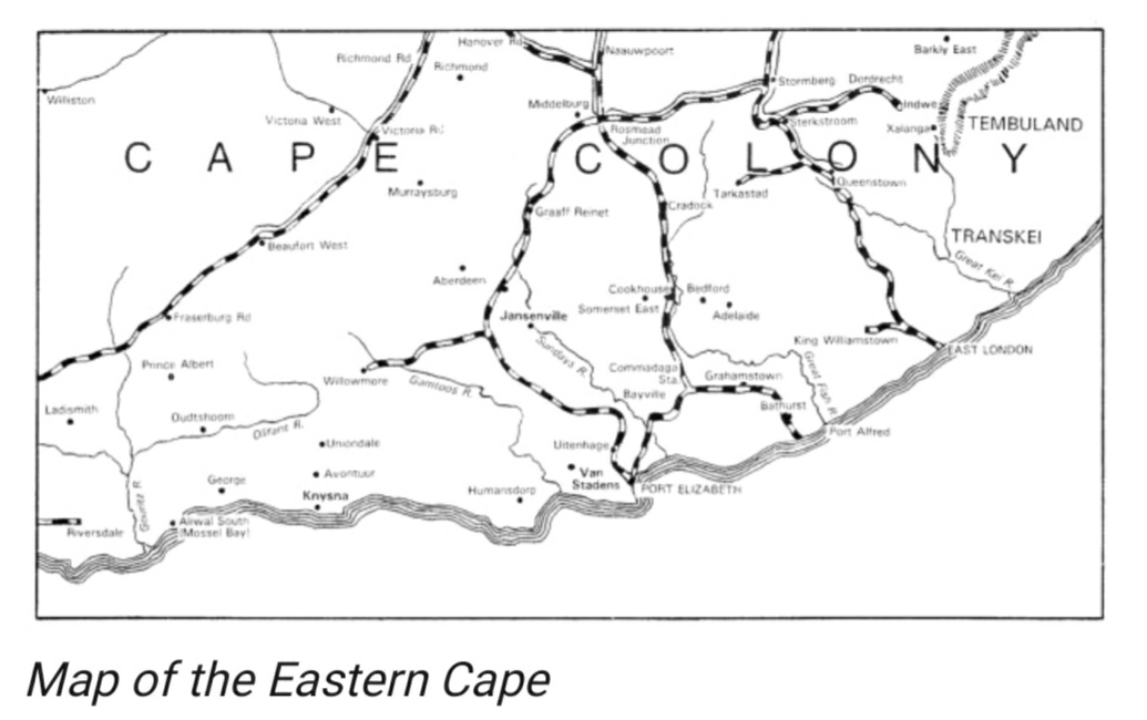
The town of Jansenville is located in the Noorsveld, an area known for its dry, arid climate and its abundance of succulents, and about 90 kilometers south from Graaff-Reinet in the east of the then Cape Colony under British rule.
The town was founded in 1854 on the farm Vergenoegd, which was owned by Petrus Jacobus Fourie. The town was named
Jansenville in honor of General Jan Willem Janssens, the last Dutch Governor of the Cape of Good Hope.
Jansenville quickly grew into a thriving agricultural community. The town’s location in the Noorsveld made it ideal for farming sheep and goats. In the late 19th century, Jansenville became a major centre for the mohair industry.
https://samilitaryhistory.org/vol102rt.htlm
Second Anglo Boer War: 1899 – 1902
Soon after the first shots were fired between the Boers and the British on the 11October 1899; the repercussions of loyalties were felt in Jansenville. It pitted the many the Dutch speaking residents against their English neighbours. Although a number of the Dutch inhabitants were loyal to the Colonial Administration the majority favoured the cause of the Boers with the result that Martial Law was proclaimed, and the town and district came under military occupation set up by Captain Gould.
Some alarm had been caused by British reverses on both fronts during the ‘Black Week’ of 09-15 December 1899. As a result of this, Port Elizabeth had decided to form a Town Guard in February 1900. However, it was the invasion of the Cape Colony by General Kritzinger’s commando of 2 000 Boers in December 1900 which caused several towns to look seriously to their defences in the early months of 1901.
In his book Commando: A Boer Journal of the Boer War, Deneys Reitz describes the progress of the Smuts Commando through the eastern Cape Colony from the Bedford/Adelaide area to the Commadaga Station on the Port Elizabeth-Cookhouse railway line, thence into the Zuurbergen Mountain Range and down to a point just north of Bayville (present-day Kirkwood). From there, the commando headed north-westwards, passing close to Jansenville on their way to Aberdeen and the Camdebo Mountains. This occurred in September and October 1901, and doubtless kept the Town Guards on the defensive.
Little of consequence happened over the next 15 months until January 1901 when the town of Jansenville was abuzz with excitement.
It was on a Sunday in January 1901 that the volunteer Town Guard at Jansenville, supplemented by British troops, all under Captain Gould, began the construction of Jansenville Fort and two blockhouses
The stone fort stands prominently on a hill on the west side of the Graaf-Reinet road on the north of the town. The Town Guard also erected a blockhouse on a knoll by the bridge over the Sundays River and another at the intersection of Main and Bridge streets,
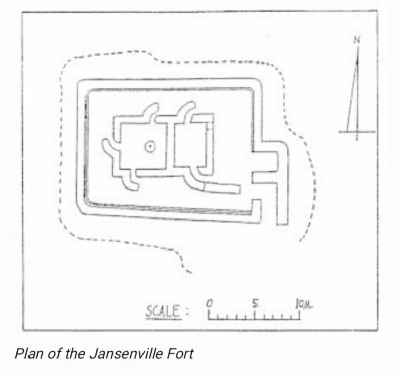
Key features of the fort:
• Location:
The fort is situated on a hill overlooking the town of Jansenville, providing a strategic vantage point
• Design:
The fort’s walls are constructed from stone blocks without mortar, standing 2 meters high with a thickness of 80-120cm.
The walls have tapered loopholes at staggered at two different levels, intervals of 1-1.2 meters
• Layout:
The fort features a detached block in the middle, forming two rooms or enclosures that served as officers’ quarters or shelters.
• Protected entrance:
The entrance, located at the southeast corner, features a right-angled turn, prevent direct views of the interior, providing additional protection.
• Internal quarters:
The centre of the fort has a detached block with two rooms. These were protected by curved screen walls to shield occupants from stray bullets and likely served as officer quarters or
shelters. These rooms may have been roofed and could have served as officers’ quarters or as shelters in wet weather (The roofing could possibly be made of materials like thatch, canvas, or
corrugated iron, which were common during the Anglo-Boer War era) A survey beacon was later placed in the west room.
• Builder: It was constructed under the supervision of the Royal Engineers, indicating a high level of sophistication
• Dry-stone construction:
The builders used unmortared masonry, yet the fort’s robust construction has allowed it to survive for over a century.
The hilltop was first levelled to create a platform, a sophisticated building technique typical of blockhouses overseen by the Royal Engineers.
• Purpose:
The fort was built by the Town Guard under Captain Gould’s command to protect the town against Boer commandos during the Second Anglo-Boer War.
• Part of a larger defensive system:
The Town Guard also erected two other blockhouses—one at a bridge over the Sundays River and another at a town intersection—but these have not survived.
The fort was part of a broader strategy to control the Jansenville district, which was a region of activity during General Smuts’s entry into the colony
• Bypassed by General Smuts:
In 1901, Boer General Jan Smuts and his commando passed within 300 yards of the fort but opted not to attack it, instead moving on to Aberdeen. Smuts later
remarked that he bypassed the “highly armed fort and impenetrable noors” (a local succulent)
• Other fortifications:
In addition to the stone fort, the Town Guard also built two smaller blockhouses. One was near the bridge over the Sundays River and the other at the intersection of Main and Bridge
streets. These two blockhouses no longer exist.
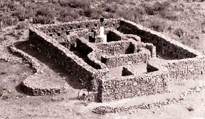
Janseville Fort
https://samilitaryhistory.org/vol102rt.htlm
https://samilitaryhistory.org/vol102rt.htlm
- The measures approximately 21m x 15m overall. The outer walls are at a height of approximately 2m, varying in thickness from 800mm to 1200mm, and are provided with tapered loopholes. The entrance to the fort is at the south-east corner and has a right-angled turn in its passage. In the middle of the fort was a detached block, which formed two rooms or enclosures, both of which could be entered by several doorways, protected externally by curved screen walls, presumably to shield the occupants from possible stray bullets which could have passed through the loopholes in the outer walls. These rooms may have been roofed and could have served as officers’ quarters or as shelters in wet weather.Another interesting feature is that, before commencing construction, the builders levelled the hilltop to form a roughly flat platform that projects 2 to 3 meters beyond the outer walls and is edged with larger stones. This is a sophistication that is generally found only with blockhouses constructed under the supervision of the Royal Engineers.
The Jansenville Fort did not see much action during the war however the District was contested by the Boer Commandos.
In November 1901, General Jan Smuts together with his Commandos’ entry into the colony was the signal for armed insurrection and, as far as the Jansenville district was concerned, two of Stefaans Fourie’s sons, Pieter and Louis, were the most active in support of the Boer cause – and within a few days had collected a following from the areas of Uitkomst, Blaaukrantz and Hottentotsfontein – and made contact with Smuts’s followers. Pieter Fourie was later killed, while Louis was wounded in the fight at Aberdeen. The fight between the British and the Boers at Blaaukrantz 20 km north of Jansenville, took place on 21 March 1901. Casualties: Boers, one wounded. British, 3 killed and buried in Paardefontein cemetery.In November 1901, General Smuts with a party of selected men, passed through the district on his way to the Zuuberg and then to northwest. He took the old disused transport road, and at Poortjie, 5 Km from Jansenville, he slept in the house where Sid Fourie was born, and passed within 274m of the fort en route to Aberdeen.
General Jan Smuts
The farm Bedrogsfontein, now below the Darlington Dam, belonged to Philip Weyer during the Anglo-Boer War. The Boers were aware that the British intended to transport cannons from Algoa Bay to the Free State for their move towards Pretoria. It was General Smuts’ plan to capture these cannons from the British and use them on the British.
Bedrogsfontein was on the Sundays River and its location in the mountains was perfect for an ambush. Smuts placed two men in a kloof at a narrow port that he realized the British had to travel through, with instruction to fire two shots when the British moved through the port.
Unfortunately for Smuts, the plan went awry as the donkeys pulling the cannons were unable to stay in their pairs and pulled loose from their harnesses. The British had to shoot two of the donkeys before proceeding. The Boers thought this was the signal and attacked, to no avail, as the British were nowhere near the ambush spot. The attack failed and the cannons, after a brief skirmish continued on their way.
The activities of the Smuts Commando later in the year caused another flutter of activity in Jansenville, when it passed within 300 yards (274 m) of the fort en route to Aberdeen.
“In 1921, during a luncheon held in his honour in Jansenville, General Smuts commented ‘It’s twenty years ago that I was in this area, when I had to bypass your town. On that occasion, I would very much have liked to have called in for a chat and a cup of coffee, but for your highly armed fort and impenetrable noors.”
It was at Bedrogsfontein that General Smuts took Ill after he had eaten from tuhe fruit of a Cactus plant. He was nursed to health by a few Dutch ladies at Kommandkraal above Vaaldraai.
Epilogue:
The fort has been renovated in 2011 to the same status as when it was built in 1901 and can be visited by arrangement
References:
https://mindtrip.ai/attraction/jansenville-eastern-cape/anglo-boer-war-fort/at-KcLU9uO
https://samilitaryhistory.org/vol102rt.htlm
https://samilitaryhistory.org/vol094dd.htlm
